Scrapbook 2: Jun 1962 — TIROS-5, Telstar, X-15
Orbiting Tiros V May Pave U.S.-Russ Path
CAPE CANAVERAL (AP) — America’s newest weather satellite, Tiros V, orbiting on its hurricane-and-storm-hunting mission, may prove to be the first step toward a cooperative space program between the United States and Russia.
The weather-watch satellite, launched Tuesday from Cape Canaveral, will photograph cloud cover over a much greater area of the world than any of the previous four Tiros satellites. Included is the sky above most of the Soviet Union.
During its anticipated four-month useful lifetime, Tiros V’s two wide-angle cameras are expected to snap hundreds of pictures of weather systems over Russia. A National Aeronautics and Space Administration official said the photographs will be available to Soviet Meteorologists if they want them.
Presumably the Russians will ask for the pictures. Earlier this month, American and Soviet scientists signed a pact in Geneva agreeing to share data received from their respective weather satellites—with a long-range look at possibly building a broad mutual space research program.
The representatives of the two major space powers also discussed the possibility of coordinating tracking, launch dates and satellite objectives to reduce exploration overlaps. There was no provision for a common launching.
As yet, Russia has not launched a weather satellite. It reportedly is developing one, but it is not known whether it is similar to the Tiros system.
The pact was the first concrete result of an exchange of letters earlier this year between President Kennedy and Premier Nikita S. Khrushchev.
The non-controversial meteorological satellite was selected as the first area of discussion, with communications satellites expected next. Further discussions between the scientists of the two nations are scheduled soon in Moscow.
Meanwhile, Tiros V whizzed about the earth every 100.5 minutes at peak speed of 17,140 miles an hour and altitudes ranging from 367 to 604 miles.
A guidance error shot the satellite higher than planned. But this did not interfere with its camera eyes.
On the first orbit, the vehicle transmitted pictures of cloud cover over the southeastern United States and a few orbits later relayed photos of storm clouds off Newfoundland. The cloud details provide vital information on what conditions exist for various weather patterns.
Hurricane Season
The launching was timed to coincide with the 1962 hurricane season, which began last week. However, tropical storm activity normally does not reach a peak until late August and September, and Tiros V’s cameras are geared to be aimed at the spawning grounds in that period.
With its wider coverage—including all territory between the Arctic and Antarctic circles—Tiros V will be able to record Pacific typhoons, ice breakup, and fog and large storm systems in the northern latitudes. Ground stations can command its cameras to photograph a suspected weather disturbance practically anywhere in the world.
Two more Tiros satellites are planned in an experimental program whose goal is the start of an operational weather satellite system by next year. A network of operational satellites, called Project Nimbus, would provide continuous weather coverage over all areas of the globe.
WEATHER WISE—Tiros V, a weather-eye satellite, heads for successful orbit in the nose cone of a three-stage Thor-Delta rocket at Cape Canaveral. —Associated Press Photo
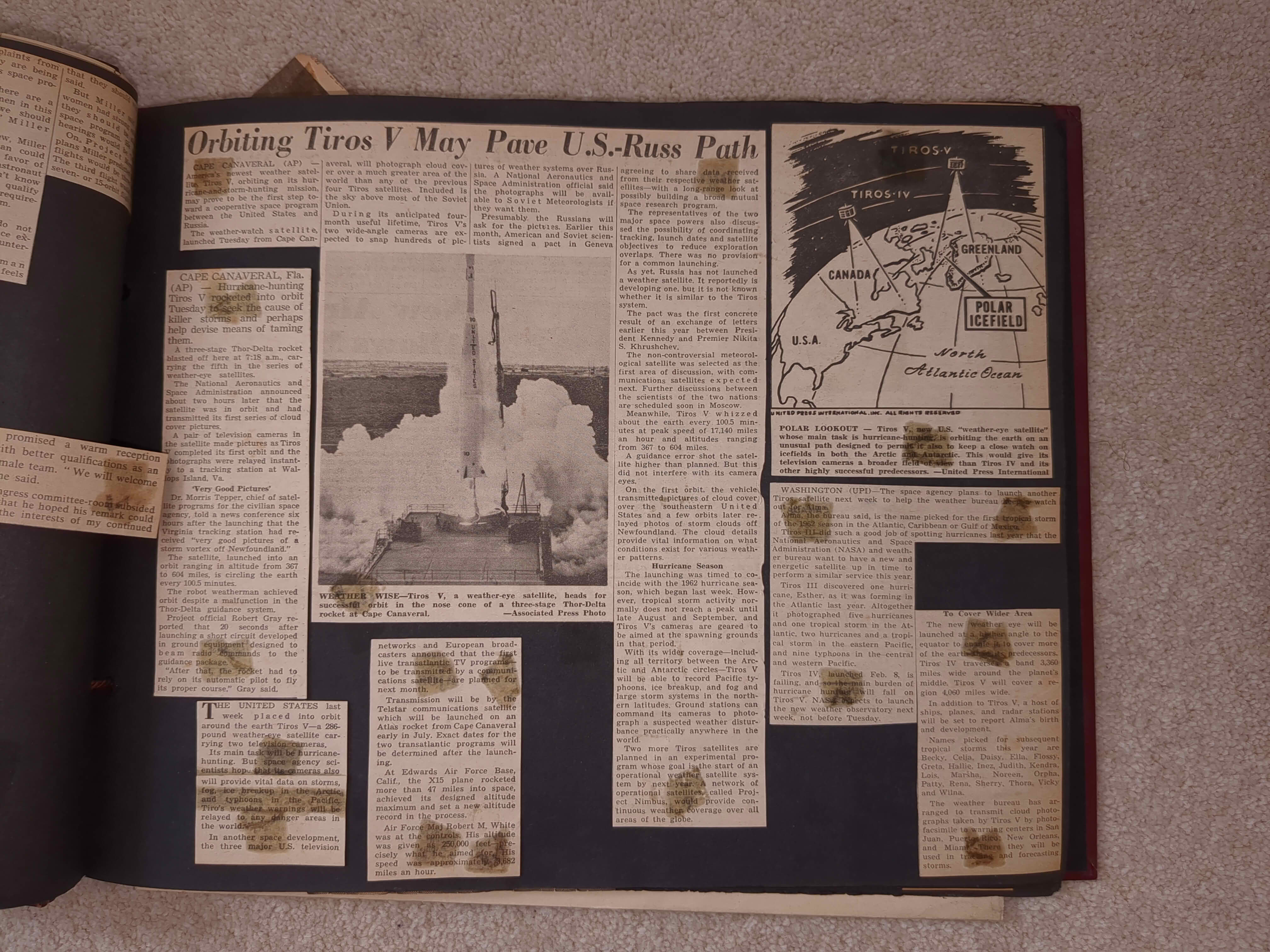
POLAR LOOKOUT — Tiros V, new U.S. “weather-eye satellite” whose main task is hurricane-hunting, is orbiting the earth on an unusual path designed to permit it also to keep a close watch on icefields in both the Arctic and Antarctic. This would give its television cameras a broader field of view than Tiros IV and its other highly successful predecessors. —United Press International
CAPE CANAVERAL, Fla. (AP) — Hurricane-hunting Tiros V rocketed into orbit Tuesday to seek the cause of killer storms and perhaps help devise means of taming them.
A three-stage Thor-Delta rocket blasted off here at 7:18 a.m., carrying the fifth in the series of weather-eye satellites.
The National Aeronautics and Space Administration announced about two hours later that the satellite was in orbit and had transmitted its first series of cloud cover pictures.
A pair of television cameras in the satellite made pictures as Tiros V completed its first orbit and the photographs were relayed instantly to a tracking station at Wallops Island, Va.
‘Very Good Pictures’
Dr. Morris Tepper, chief of satellite programs for the civilian space agency, told a news conference six hours after the launching that the Virginia tracking station had received “very good pictures of a storm vortex off Newfoundland.”
The satellite, launched into an orbit ranging in altitude from 367 to 604 miles, is circling the earth every 100.5 minutes.
The robot weatherman achieved orbit despite a malfunction in the Thor-Delta guidance system.
Project official Robert Gray reported that 20 seconds after launching a short circuit developed in ground equipment designed to beam radio commands to the guidance package.
“After that, the rocket had to rely on its automatic pilot to fly its proper course,” Gray said.
THE UNITED STATES last week placed into orbit around the earth Tiros V—a 286-pound weather-eye satellite carrying two television cameras.
Its main task will be hurricane-hunting. But space agency scientists hope that its cameras also will provide vital data on storms, fog, ice breakup in the Arctic and typhoons in the Pacific. Tiro’s weather warnings will be relayed to any danger areas in the world.
In another space development, the three major U.S. television networks and European broadcasters announced that the first live transatlantic TV programs—to be transmitted by a communications satellite—are planned for next month.
Transmission will be by the Telstar communications satellite which will be launched on an Atlas rocket from Cape Canaveral early in July. Exact dates for the two transatlantic programs will be determined after the launching.
At Edwards Air Force Base, Calif., the X15 plane rocketed more than 47 miles into space, achieved its designed altitude maximum and set a new altitude record in the process.
Air Force Maj Robert M. White was at the controls. His altitude was given as 250,000 feet—precisely what he aimed for. His speed was approximately 3,682 miles an hour.
WASHINGTON (UPI)—The space agency plans to launch another Tiros satellite next week to help the weather bureau keep a watch out for Alma.
Alma, the bureau said, is the name picked for the first tropical storm of the 1962 season in the Atlantic, Caribbean or Gulf of Mexico.
Tiros III did such a good job of spotting hurricanes last year that the National Aeronautics and Space Administration (NASA) and weather bureau want to have a new and energetic satellite up in time to perform a similar service this year.
Tiros III discovered one hurricane, Esther, as it was forming in the Atlantic last year. Altogether it photographed five hurricanes and one tropical storm in the Atlantic, two hurricanes and a tropical storm in the eastern Pacific, and nine typhoons in the central and western Pacific.
Tiros IV, launched Feb. 8, is failing, and so the main burden of hurricane hunting will fall on Tiros V. NASA expects to launch the new weather observatory next week, not before Tuesday.
To Cover Wider Area
The new weather eye will be launched at a higher angle to the equator to enable it to cover more of the earth than its predecessors. Tiros IV traverses a band 3,360 miles wide around the planet’s middle. Tiros V will cover a region 4,060 miles wide.
In addition to Tiros V, a host of ships, planes, and radar stations will be set to report Alma’s birth and development.
Names picked for subsequent tropical storms this year are Becky, Celja, Daisy, Ella, Flossy, Greta, Hallie, Inez, Judith, Kendra, Lois, Marsha, Noreen, Orpha, Patty, Rena, Sherry, Thora, Vicky and Wilna.
The weather bureau has arranged to transmit cloud photographs taken by Tiros V by photofacsimile to warning centers in San Juan, Puerto Rico, New Orleans, and Miami. There they will be used in tracking and forecasting storms.